Chennai Walkabout

Today, we're counting shopfronts and apartment buildings, trying to get a rough count of how many residences are in an area so that they can make some informed assertions about community composting, waste collection, and water management. Matching the Google satellite views with houses on the ground, one of the researchers notice that the streets in the image don't line up with the streets on the ground. We do a little bit of detective work and realize that a dead-end has been filled in by a new building with a dress shop, and a through-street became a dead end when a new house was constructed. They interview the neighbors. Who remembers when these buildings went up?
Chennai has no mechanisms for overseeing the basics of community control of its streets. There is no centralized office capable of taking in the wealth of information generated by a rapidly expanding city. If Transparent Chennai becomes the arbiter of information for the city, then the NGO stands to replace many of the traditional functions of city government. Would volunteers be numerous or rigorous or committed enough for tasks as diverse as counting the census, or watching houses? Will Transparent Chennai be replaced by private city accounting firms, watching over water points and manholes? We spend the evening talking about the future of government, wondering what the experience of other mappers will tell us about their successes.
Volunteers go into the ward for 2-8 hrs every day. The 8 hr days are exhausting in Chennai's damp heat: three hours from 8 to 11 in the morning, a break for lunch, another three hours in the afternoon, and two more after a break in the evening.
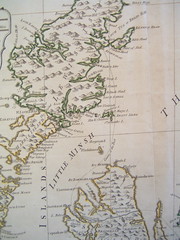
The paper maps are printouts of satellite photography available via Google Maps. The volunteers draw directly onto the maps, noting uncollected garbage, water points, toilets, the number of dwellings on every building on a street, or shop fronts. They've conducted "walkability" surveys of neighborhoods in Chennai, where sidewalks are broken and huge holes gape into unsculpted pits of mud beneath, where loose electric wires hang from the trees above, where scooters and cars parked on the sidewalk force pedestrians to walk in the busy carriageway, facing down auto-rickshaws and scooters and busses flying by a few inches away. They note the speed of vehicles, the number of obstructions, the materials used in making sidewalks, the condition of the walking path, amenities such as seating, trashcans, and toilets, parking on the sidewalks, crossing points, and so on. They map the distance that people are walking to cross the road. They mark trees, storm water drainage, the number of driveways, manholes, utility boxes -- which in Chennai are in the middle of the sidewalk. Their questions are ultimately urban planner questions. Paper maps are then inputted to ArcGIS.
That morning at the office, the staff of researchers and activists have questions about the scale of mapping appropriate to different kinds of political action. When are paper maps appropriate, and when is GIS appropriate? When is it enough to map water for the neighborhood, and what sorts of questions require them to map the whole of Chennai, or the region, or indeed India, to draw together the sort of argument they need? They are in the process of matching technology to larger questions.
These are exactly the sorts of problems that the next generation of infrastructure will have to answer, questions about mobilizing political will, using information to do so, and the appropriate scale for working in such a way as to include all the constituents of a community. (Photo credit and further reading: "Civic Sens(E)itivity" by Zara Khan and Tanya Thomas.
posted by Jo Guldi at 3:23 AM
![]()
![]()


0 Comments:
Post a Comment
<< Home