Locals and Tourists: The Maps of Collective Imaginations
 About a year ago, I started asking my graduate students in digital history about a complicated problem: sorting photos, not text, for cultural data. When humanities professors go digital, typically they tackle text first. Humanities professors, schooled on books and sorted by proficiency in the math-and-numbers testing of the SAT and GRE, are (like most of our text-based culture) fluent with words, not pictures. The genera of research projects they attempt are based in text. They sort court cases for redundant terms; they try to identify the relationships between individuals in the Domesday book, or they tally the programs from the eighteenth-century theater -- all sorting games that effectively involve sophisticated flavors of keyword search. Like most of search software for the internet, humanities professors can only get you to what we know about text-based culture.
 But scholars have long been aware of a universe of visual signifiers, exchanged beyond the scope of literate elites among the illiterate masses. Even in an age of mass literacy, 90% of experience is visual, and the built environment, advertising, the commodity, gesture, and ritual constantly fill the visual cortex with new messages about social reality.
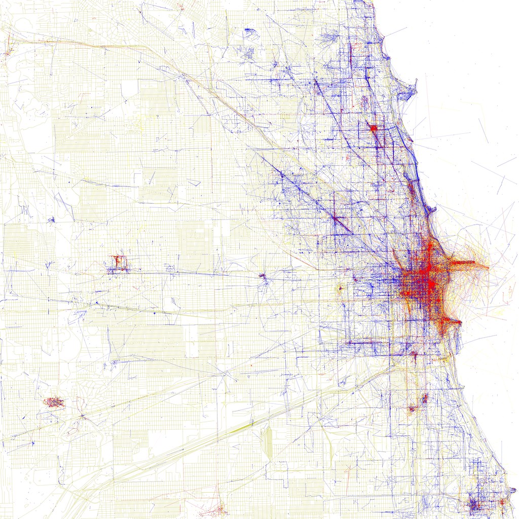
Since "local" and "tourist" maps appeared on Eric Fischer's flickr site, however, the humanities have a hard prod to try something more visual.
The Local v Tourist map is the first attempt to map a collective *visual* (rather than textual) imagination. By dividing the population into two groups -- locals and tourists -- the maps manage to point at one of the foundational terms of modern sociology and anthropology. The key term was "world view." From the 1880s forward, philosophers, anthropologists, sociologists and art historians fixated upon "world view" as a category for understanding how different demographics use and move through a city, a forest, a market, or government in very different ways.
"World view" is always studied through the use and experience and naming of everyday places, which makes social networks in flickr such a perfect way of studying it. Further horizons include the ability to show you something like "the Chicano city" or "the teenager city" and invite the traveler to really become a traveler into different peoples' worlds -- not just into the social imaginary of the city as presented by Disney or Fodor.
The next step, it seems to me, is using photosynth to agglomerate something about the local/tourist city -- even "averaging" houses, monuments, museums, parks, or people from local v tourist. Or, as Bethany Nowviskie prods me, averaging colors and angles used by locals and tourists. Or, if one is using film-in-time rather than pictures to make an argument: smooshing them together into a VR tour of the local v tourist city.
One of the grants I wrote last year was for a nonprofit in Chicago with thousands of landscape photographs taken by youth of color. We were imagining building something like this to sort their photographs, then building a mobile phone app to help bring in new photos with GPS and social networking metadata.
All of this represents a new way of thinking about how people deal with the spaces around them -- how to see into the world views of different cultures, the overlapping planes of culture in real space. And *that* represents the real horizon of synthetic research in historical landscape photographs, maps, and travel-guides.
If we can build a world-view-surfer for Chicago on Flickr, we can build it for French and English explorers with the Newberry library maps & guidebooks on Google Earth. The old historical chestnut was that the French went by river; the English by land, and their cities, landscapes, and language developed accordingly. What other patterns are out there?
Overlapping world views, transposed onto the same space: synthesizing and averaging images to give an overview of how different cultures use landscape -- this is the horizon of a vast and little-known frontier.
There's room for much building yonder. Neither the Googles of the world, nor the visual analysts of computer science departments, nor scholars of the visual humanities have come up with tools sufficient to differentiate World View. But the material is vast.
Labels: digital humanities, imagination, landscape, search, visualization
posted by Jo Guldi at 6:04 PM
![]()
![]()


1 Comments:
Sign me up for such an endeavor. As you note, it has the potential to span everything from artistic practice to social activism to scholarly work.
Post a Comment
<< Home